The project has the goal of understanding the Angolan side of the Kalahari-Ohangwena (KOH) transboundary multilayered aquifer system (Angola and Namibia), located in the sedimentary basin of Cunene. This aquifer system can reach more than 300 meters in thickness and is mainly composed of intercalations of clay and sands. It comprises several aquifers (divided majorly into KOH-0, KOH-1 and KOH-2) with very different characteristics, either regarding flow rates or groundwater quality. The study was especially focused on the deep aquifer KOH-2, which is known to contain freshwater that can be in the future regarded as a potential groundwater supply for the people of Cunene.
After the interpretation of surface geophysics (vertical electrical soundings from the 1960s and time-domain electromagnetics carried out within the scope of the project), a set of boreholes with a maximum 300m depth were planned, drilled, and converted into monitoring piezometers.
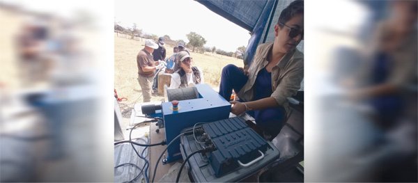
Geophysical logging was conducted to identify and characterise the aquifers that compose the KOH aquifer system and to define the screens’ location for deep wells so that monitoring of the KOH-2 could be possible soon. Borehole logging surveys in previously drilled deep wells were also conducted.
Training was also an important part of the PLANAGEO project. Therefore, a team of Angolan technicians from IGEO and the regional Cunene authority received geophysical logging training as part of a major training program. In the future, the logging equipment will be used by the Geological Survey of Angola (IGEO) and will become part of their skills and provided services. Robertson Geo supplied the suite of probes and wireline surface deployment and data acquisition system.


